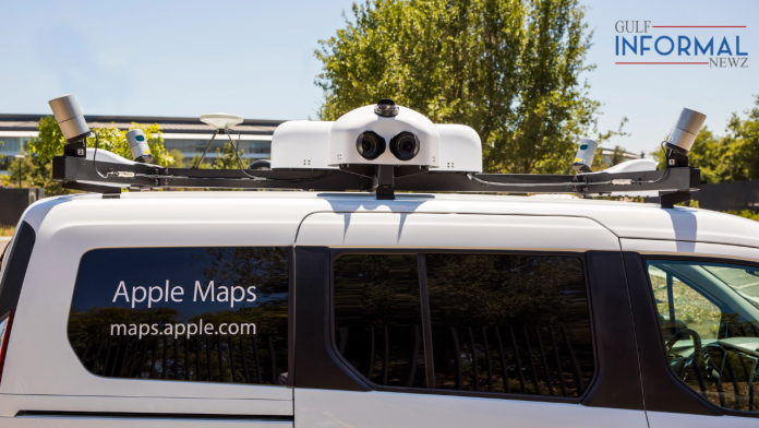
Apple is set to begin an extensive data collection process across Dubai to update and improve its Maps services. Starting March 7, residents will see Apple-branded vehicles driving around the city streets as part of this effort.
In addition, individuals carrying specialized backpacks will gather mapping details from pedestrian-only areas until June 15. Equipment-packed vehicles will explore Dubai’s road while those on foot will gather information about pedestrian-only areas in the emirate.
“Apple is conducting ground surveys with vehicles around the world to collect data to improve Apple Maps and to support the Look Around feature. Vehicle surveys may use equipment mounted on the outside of vehicles as well as iPhones, iPads, or other devises inside of vehicles,” Apple spokesperson said in a statement to Khaleej Times.
In order to completely reconstruct its global map over the past few years, Apple has driven millions of miles with vehicles packed with sophisticated image and Light Detection and Ranging (LiDAR) collection technology — a remote sensing method. These regular surveys in major global cities will be used to upgrade key features of Apple Maps that was first introduced in 2012.
Also Read: UAE: Bitcoin Donations Allowed for Charity During Ramadan
The tech giant is updating more nations each year, and the updated map has already been made available in the US, Canada, Australia, Singapore, and other places.
Up-to-date map
Apple Maps, which made UAE debut in 2017, and the subscribers can use the service through an iPhone, iPad, Mac or Apple Watch.The system offers directions in English and Arabic for journeys whether driving or walking.
“We may periodically revisit and re-collect data in some of those locations in an effort to maintain a high-quality, up-to-date map,” according to Apple spokesperson.
“Apple is also conducting surveys with portable systems in select pedestrian areas. Some pedestrian surveys use a backpack system to collect data that may be used directly in Apple Maps, such as in the Look Around feature.
“Other pedestrian surveys use iPads, iPhones or other devices to collect data for map improvement purposes. These pedestrian surveys allow us to improve and update Apple Maps in areas where vehicles simply can’t go while using the same privacy protections as the Apple Maps vehicles,” the spokesperson added.
The backpack data gathering system is a more compact version of the vehicle collection system, but still allows for collection of LiDAR point cloud and imagery. Data collection through backpacks can cover pedestrian only streets, parks, plazas and transit stations where data can be used to create 2D maps.
The data collection drive highlights Apple’s commitment to constant progress. By regularly rebuilding maps from the ground up, it ensures users always have access to accurate, current mapping data regardless of their destination. This benefits both residents and visitors of Dubai in turn. The upcoming months will see many benefitting from these efforts to upgrade the digital experience and services in the emirate.
Also Read: Indian Consulate in Dubai launches new insurance package for these workers


